- Mon. Apr 6th, 2026
Latest Post
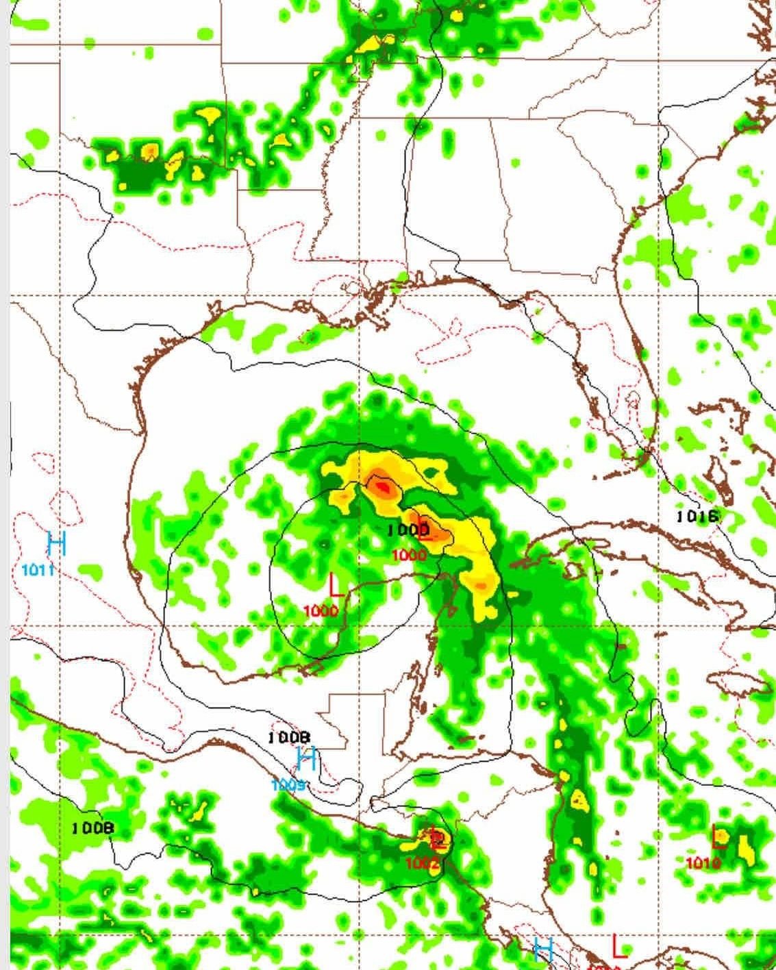
 Tropical Update 06/26/2025 Hurricane Tracker Hub
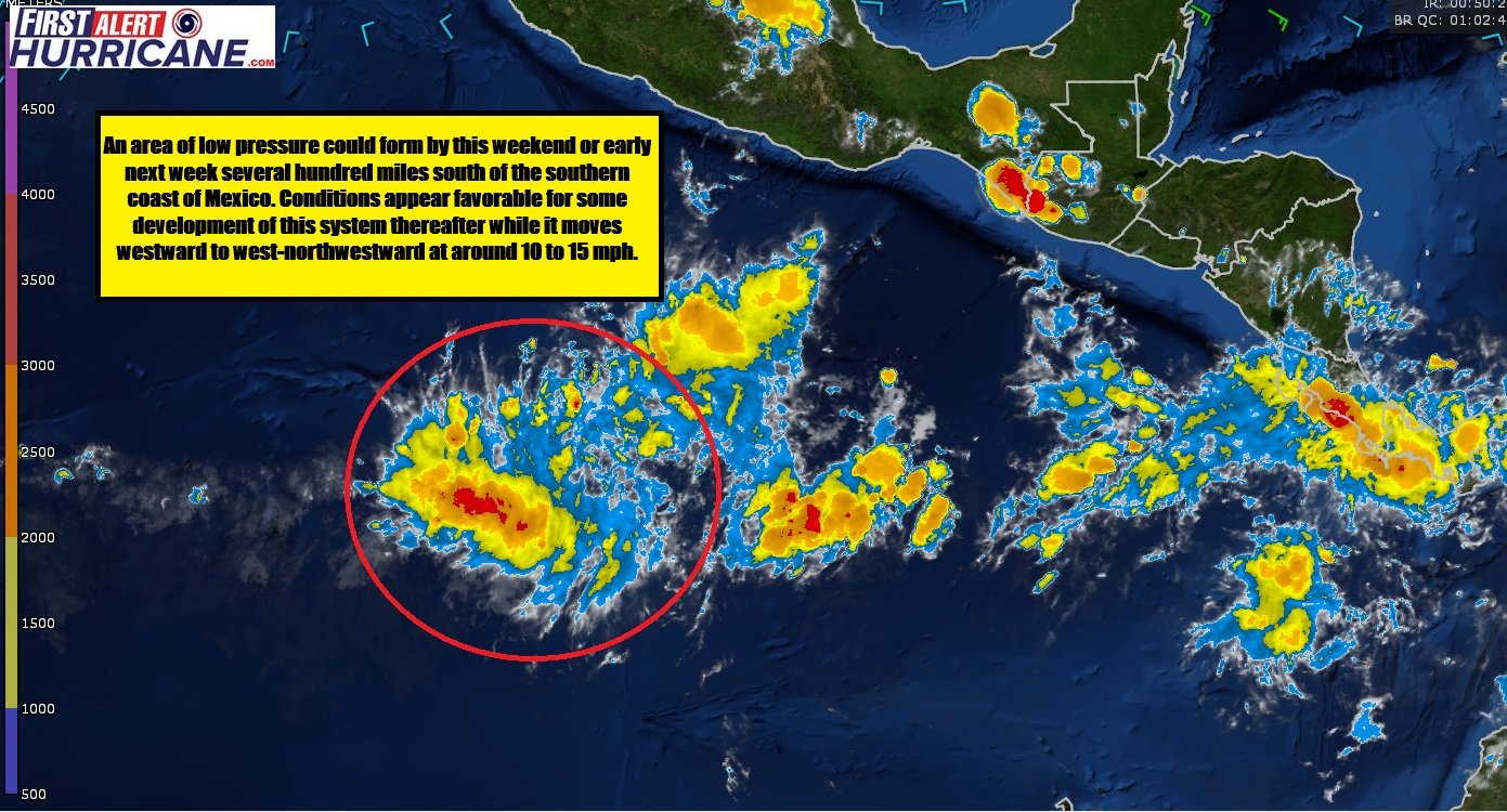
 Tracking Invest 95-E in the Eastern Pacific
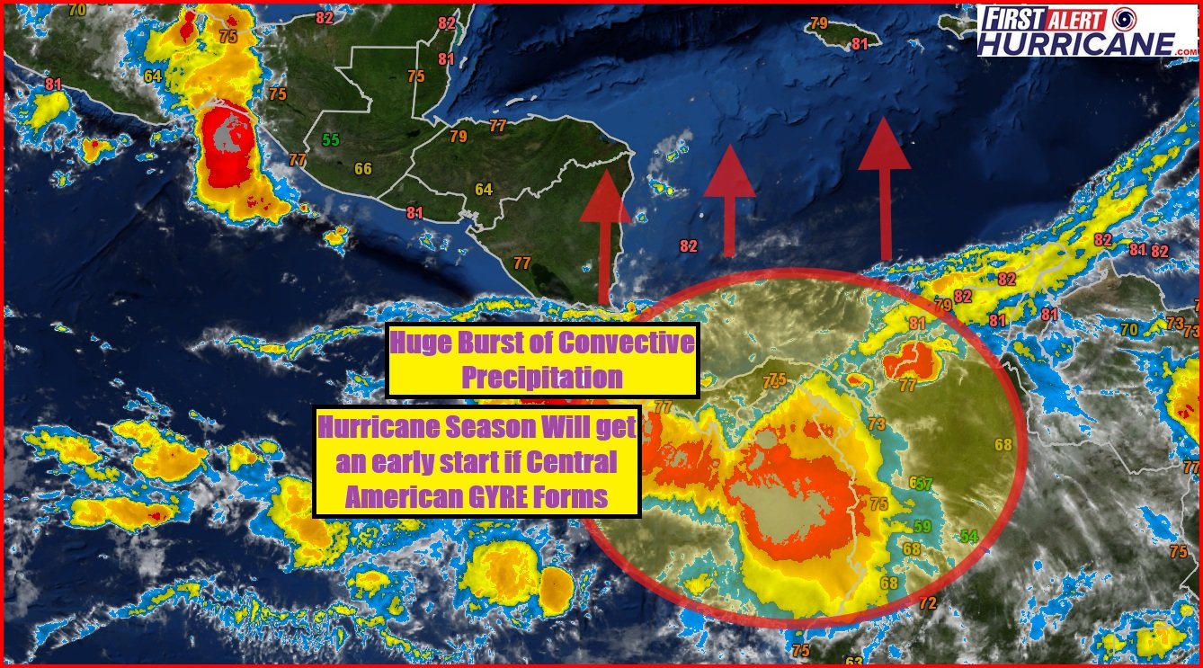
 The Central American Gyre itself can cause heavy rainfall and flooding in Central America
 First Day of 2025 Hurricane Season and Something is already Cooking in the Tropics
 Atlantic hurricane season is predicted to be above normal for 2025
Ever Wanted to know how to Read Skew-T Charts?
If you haven’t seen a Skew-T chart before, to say they can look a little intimidating is a huge understatement. But with a little practice, you can become a Skew-T…
Florida Weather Blog
Gulf Coast Weather Blog
Hurricane Blog
Mississippi Weather Blog
Pine Belt Weather Blog
Weather this weekend in the Pine Belt and Gulf Coast not Bad!!!!
The northwest flow pattern is expected to persist through the weekend, and the models are in decent agreement that another shortwave trough will push through the region on Saturday. In…
Florida Weather Blog
Gulf Coast Weather Blog
Hurricane Blog
Mississippi Weather Blog
Pine Belt Weather Blog
Severe Weather for Parts Mississippi and Not as Cold for the Pine Belt
A robust and quick moving storm system will track from the Red River Valley Friday night into the Midsouth by Saturday morning, bringing a cold front across the area early…
Florida Weather Blog
Gulf Coast Weather Blog
Hurricane Blog
Mississippi Weather Blog
Pine Belt Weather Blog
Severe Weather and Bitter COLD Temps for the Pine Belt this Weekend…
The main focus for this portion of the forecast period is on late Friday night through Saturday when a significant frontal system is expected to plow through the Lower Mississippi…
Hello world!
Welcome to WordPress. This is your first post. Edit or delete it, then start writing!
Florida Weather Blog
Gulf Coast Weather Blog
Hurricane Blog
Mississippi Weather Blog
Pine Belt Weather Blog
The Pine Belt can expect 1″ to 3″ of Rain on Thursday: Ending Friday Sunny and Cooler
Expect the rainfall to let up a little bit after midnight tonight and through the morning hours on Thursday as the frontal forcing relaxes, though there will still be some…
Florida Weather Blog
Gulf Coast Weather Blog
Hurricane Blog
Mississippi Weather Blog
Pine Belt Weather Blog
More Flooding Rains for the Pine Belt but much Sunny and Cooler for the Weekend
Wet weather will continue into Thursday as a TX Panhandle upper low tracks eastward toward the area. Ahead of this feature, a departing upper jet max over the Ohio Valley…
Florida Weather Blog
Gulf Coast Weather Blog
Hurricane Blog
Mississippi Weather Blog
Pine Belt Weather Blog
The Pine Belt New Year Weather Forecast
As a shortwave lifts from the Southern Plains toward the Great Lakes today, its developing surface low should track from Arkansas toward Indiana. This will bring a cold front through…
Florida Weather Blog
Gulf Coast Weather Blog
Hurricane Blog
Mississippi Weather Blog
Pine Belt Weather Blog
After a Wet Period;The Pine Belt will enjoy Cooler and Dryer end of the week
As a shortwave lifts from the Southern Plains toward the Great Lakes on Monday, an attendant surface low should track from across eastern Arkansas toward Indiana during the daytime. Due…
Florida Weather Blog
Gulf Coast Weather Blog
Hurricane Blog
Mississippi Weather Blog
Pine Belt Weather Blog
South Mississippi Flooding Update
A swath of rain and a couple of embedded thunderstorms will continue to push north across the area into this evening. Much of the rainfall amounts with this will be…
Florida Weather Blog
Gulf Coast Weather Blog
Hurricane Blog
Mississippi Weather Blog
Pine Belt Weather Blog
Train Of Strong Storms To Continue Impacting The Pacific Northwest This Week
The first in a series of strong Pacific storms is impacting parts of the Pacific Northwest this evening, and several more are set to bring similar impacts through the coming…
Florida Weather Blog
Gulf Coast Weather Blog
Hurricane Blog
Mississippi Weather Blog
Pine Belt Weather Blog
Our Global Warming Emergency
Thirty plus years of global warming reduction failure In spite of 30 years of warnings by credible scientists and the work of the environmental movement, plus a preponderance of collaborating…
Florida Weather Blog
Gulf Coast Weather Blog
Hurricane Blog
Mississippi Weather Blog
Pine Belt Weather Blog
High Impact Winter Storm Likely From The Southern Plains To The Southern Appalachians
Here’s a look at our main system currently as it moves SE just off of Los Angeles. The storm has been quite impactful in California, causing heavy rain and mudslides…
Florida Weather Blog
Gulf Coast Weather Blog
Hurricane Blog
Mississippi Weather Blog
Pine Belt Weather Blog
Potential Winter Storm To Usher In Warmer Pattern For East Coast Mid Month
I usually focus on near-term weather threats here, but today with generally quiet weather across the US I want to look a little farther out into the medium-long range to…
Florida Weather Blog
Gulf Coast Weather Blog
Hurricane Blog
Mississippi Weather Blog
Pine Belt Weather Blog
An Active and Destructive 2018 Atlantic Hurricane Season Ends
Despite pre-season predictions of an average to below-average year, the 2018 Atlantic hurricane season was above average by most measures, with two U.S. hurricanes—Florence and Michael—causing unusually high death tolls…
Florida Weather Blog
Gulf Coast Weather Blog
Hurricane Blog
Mississippi Weather Blog
Pine Belt Weather Blog
Your Pine Belt Severe Weather Update:
The main concern will continue to be the potential for severe weather later tonight. There remain a few questions as to how things will develop over the next 12-18 hours.…
Florida Weather Blog
Gulf Coast Weather Blog
Hurricane Blog
Mississippi Weather Blog
Pine Belt Weather Blog
Severe Weather For Mississippi this Weekend than COLD Weather returns later in the week next week
An active weather pattern will take shape for the end of the week into early next week. Primary concerns for the Pine Belt in Mississippi are for the threat for…
Here’s the Pine Belt Thanksgiving Weekend Weather Outlook
Expect a nice, dry & cooler than normal pattern over the next day as surface & mid-level ridge axis build over the region. Tonight, expect the center of the mid-level…
Florida Weather Blog
Gulf Coast Weather Blog
Hurricane Blog
Mississippi Weather Blog
Pine Belt Weather Blog
Hurricane Michael Intensifies to Category 2; May Be Florida Panhandle’s Strongest Landfall in 13 Years Wednesday
Michael is currently centered about 360 miles south of Panama City, Florida, and is moving north. (LATEST NEWS: Evacuations Ordered Along Florida Coast) A storm surge warning is in effect…
Florida Weather Blog
Gulf Coast Weather Blog
Hurricane Blog
Mississippi Weather Blog
Pine Belt Weather Blog
Michael Gains Steam in SE Gulf; Cat 3 Landfall Likely on Gulf Coast
Above: Infrared image of Hurricane Michael as of 0422Z (12:22 am EDT) Tuesday, October 9, 2018. Image credit: NASA/MSFC Earth Science Branch. Hurricane Michael was gathering strength on Monday night…