- Mon. Apr 6th, 2026
Latest Post
 Tropical Update 06/26/2025 Hurricane Tracker Hub
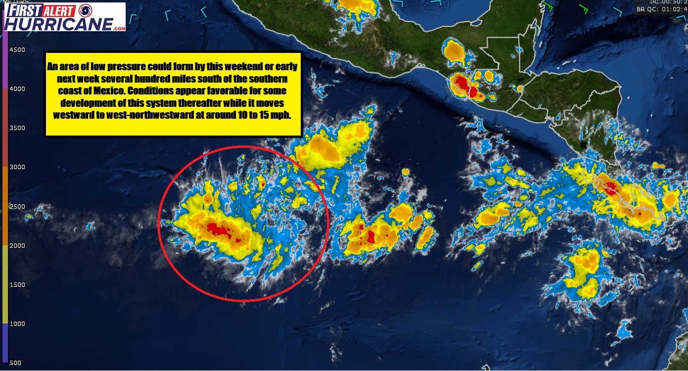
 Tracking Invest 95-E in the Eastern Pacific
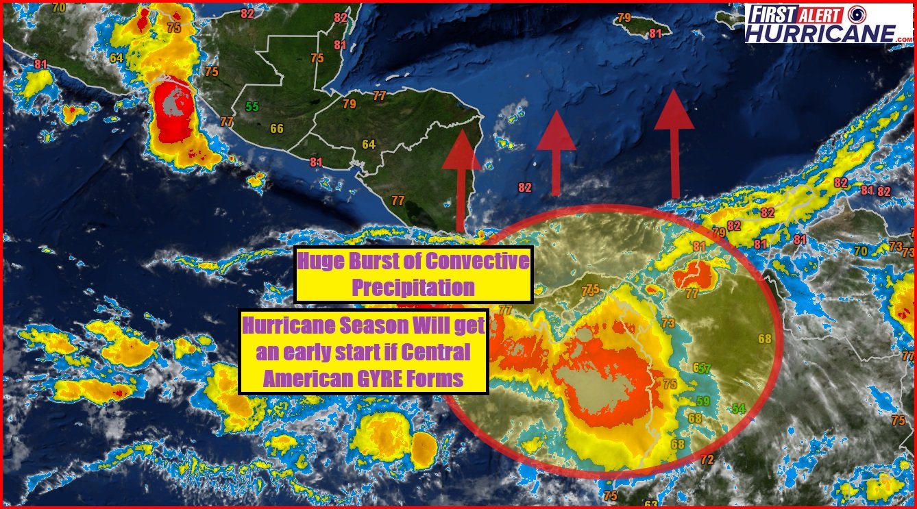
 The Central American Gyre itself can cause heavy rainfall and flooding in Central America
 First Day of 2025 Hurricane Season and Something is already Cooking in the Tropics
 Atlantic hurricane season is predicted to be above normal for 2025
Florida Weather Blog
Gulf Coast Weather Blog
Hurricane Blog
Mississippi Weather Blog
Pine Belt Weather Blog
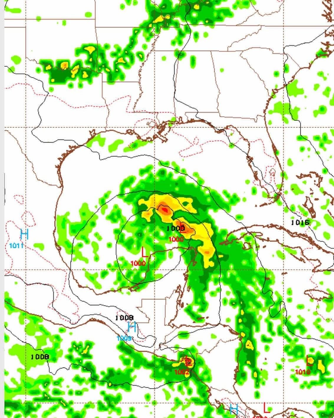
[September 1st] Tropical Wave May Develop in Gulf of Mexico Next Week
https://www.youtube.com/watch?v=-5aXu2Aw7LQ
Florida Weather Blog
Gulf Coast Weather Blog
Hurricane Blog
Mississippi Weather Blog
Pine Belt Weather Blog
Tropical Update: Why Has It Been So Quiet In The Atlantic This Month?
Today’s update will come in two parts, this being part one, focusing on the tropical Atlantic. The season has gotten off to a slow start, but we’re only just entering…
Coastal Change Hazards: Hurricanes and Extreme Storms
Hurricane Katrina Before and After Photo Comparisons: Mainland Mississippi The mainland shoreline of Mississippi, located in the right-front quadrant of Hurricane Katrina, experienced one of the greatest storm surges in…
Florida Weather Blog
Gulf Coast Weather Blog
Hurricane Blog
Mississippi Weather Blog
Pine Belt Weather Blog
One Year after Hurricane Katrina’s Surge
We’re traveling the coastline destroyed by Hurricane Katrina’s record storm surge. This is something that has never been shown on the news or talked about, either in the overall, or…
Rebuilding New Orleans: Detailing a New Vernacular
13 years ago this month, Hurricane Katrina devastated New Orleans. During the years following the levee failures, the city witnessed a boom in architectural experimentation, as small, independent developers joined…
Florida Weather Blog
Gulf Coast Weather Blog
Hurricane Blog
Mississippi Weather Blog
Pine Belt Weather Blog
NOAA Makes Winter Weather Forecast for 2018-2019 Season
The new NOAA Winter Weather Forecast 2018-2019 is here. Summer may still be in full swing, but that doesn’t mean that colder weather isn’t on the way. The meteorologists at…
Florida Weather Blog
Gulf Coast Weather Blog
Hurricane Blog
Mississippi Weather Blog
Pine Belt Weather Blog
Chris moving Away from US – Will Impact Newfoundland Thursday and Early Friday
Tropical Storm Chris is beginning to move northeastward this morning, away from the United States. Since Chris sat in the same spot for a couple days, the water beneath the…
Florida Weather Blog
Gulf Coast Weather Blog
Hurricane Blog
Mississippi Weather Blog
Pine Belt Weather Blog
Chris Becomes a Hurricane East of the Carolinas
Above: Visible satellite image of Chris as of 20Z (4 pm EDT) Tuesday, July 10, 2018. Image credit: RAMMB / CIRA @ CSU. Tropical Storm Chris became the second hurricane…
Florida Weather Blog
Gulf Coast Weather Blog
Hurricane Blog
Mississippi Weather Blog
Pine Belt Weather Blog
Beryl Significantly Weaker as We Expected
Above: Visible satellite image of Beryl from 9 am EDT Saturday, July 7, 2018. Beryl’s circulation center was exposed to view, with just one clump of heavy thunderstorms on the…
Big Drop in CSU’s Atlantic Hurricane Outlook; Quiet Atlantic, Active Pacific
Above: Sea surface temperatures (SSTs) analyzed at 2 am EDT Tuesday, July 3, 2018, across the North Atlantic, as compared to the 1981-2010 average SST for this time of year,…
Florida Weather Blog
Gulf Coast Weather Blog
Hurricane Blog
Mississippi Weather Blog
Pine Belt Weather Blog
East Pacific Overachieving, Atlantic and Northwest Pacific Underwhelming
Above: Four systems in various stages of potential development were highlighted in the tropical weather outlook issued by the NOAA/NWS National Hurricane Center at 8 am EDT Monday, June 25,…
Florida Weather Blog
Gulf Coast Weather Blog
Hurricane Blog
Mississippi Weather Blog
Pine Belt Weather Blog
Meteorologists United on Climate Change
Above: West Palm Beach broadcast meteorologist Jeff Berardelli (CBS12) with the warming-stripes graphic being used in Thursday’s Meteorologists United on Climate Change campaign. Image credit: Courtesy Jeff Berardelli. Close to…
Florida Weather Blog
Gulf Coast Weather Blog
Hurricane Blog
Mississippi Weather Blog
Pine Belt Weather Blog
Five Years after El Reno, “The Man Who Caught the Storm” Is a Stunner
Above: In this file photo from May 26, 2006, in Ames, Iowa, Tim Samaras shows the probes he was using when trying to collect data from a tornado. Image credit:…
NOAA Predicts a Near-Normal or Above-Normal Atlantic Hurricane Season; Update on 90L
Above: The strongest Atlantic hurricane of 2017, Hurricane Irma, as seen by the MODIS instrument on September 5, 2017. At the time, Irma was at peak strength, a Category 5…
Florida Weather Blog
Gulf Coast Weather Blog
Hurricane Blog
Mississippi Weather Blog
Pine Belt Weather Blog
Tropical Weather Update 10 AM 5/23/2018
The National Hurricane Center currently has a 60 percent chance that the low will become a subtropical or tropical cyclone over the central or eastern Gulf over the next 5…
Florida Weather Blog
Gulf Coast Weather Blog
Hurricane Blog
Mississippi Weather Blog
Pine Belt Weather Blog
Special Tropical Weather Outlook 05/21/2018
Special Tropical Weather Outlook NWS National Hurricane Center Miami FL 830 AM EDT Mon May 21, 2018, For the North Atlantic…The Caribbean Sea and the Gulf of Mexico: Widespread cloudiness…
Hurricane season may be even worse in 2018 after a harrowing 2017
Flooded homes at Citrus Park in Bonita Springs, Florida on 16 September 2017, six days after Hurricane Irma. Photograph: Nicole Raucheisen/AP The peak season for Atlantic storms, which officially starts…
Rare Tropical Storm in Gulf of Aden May Affect Yemen, Somalia, Djibouti
Above: Infrared satellite image of Tropical Cyclone 1A (center) and related thunderstorm activity (lower right). Image credit: RAMMB-CIRA/CSU. Tropical Cyclone 1A, which developed late Wednesday between Yemen and Somalia, could…
Florida Weather Blog
Gulf Coast Weather Blog
Hurricane Blog
Mississippi Weather Blog
Pine Belt Weather Blog
Gulf of Mexico Disturbance Bringing Heavy Rains to Florida, and May Develop
Above: GOES-East satellite image of the Gulf of Mexico disturbance, taken at 6:30 pm EDT May 13, 2018. Image credit: NOAA/RAMMB. The Atlantic hurricane season officially starts on June 1,…
Florida Weather Blog
Gulf Coast Weather Blog
Hurricane Blog
Mississippi Weather Blog
Pine Belt Weather Blog
An upper level low over the Gulf of Mexico is worth watching early in the week
The Atlantic hurricane season officially starts on June 1, but we could see a tropical or subtropical depression form in the Gulf of Mexico by Wednesday off the coast of…